TL;DR: Using Caltrans QuickMap reduces work zone crash risks by delivering real-time alerts on California’s road construction, lane closures, and traffic slowdowns. Commuters and truck drivers face the highest risk, but state law allows victims to seek compensation for injuries sustained in unsafe work zones.
Table of Contents
Caltrans QuickMap is California’s real-time traffic and work zone platform. It helps drivers stay informed by providing instant updates on road construction, lane closures, and roadway incidents.
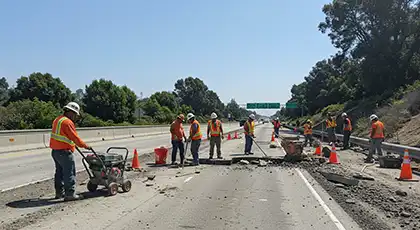
The Golden State’s highways frequently undergo ongoing construction, maintenance, or utility work to ensure roads remain safe and efficient. These projects can create temporary hazards for drivers and workers, making real-time updates important for safer travel.
With Caltrans QuickMap, you can:
- Check construction zones and lane closures before your trip to avoid delays.
- View live images from traffic cameras to see current traffic conditions.
- Receive route-specific alerts and notifications.
Whether you’re a daily commuter, commercial truck driver, or occasional traveler, this free tool is essential for anyone driving on California’s highways. Accidents can happen anywhere, anytime. Being prepared, informed, and driving defensively is key to your safety. If you sustain injuries in a crash, speak to one of our car accident lawyers for legal assistance. Call AK Law at (888) 488-1391 to schedule a free initial case consultation.
Caltrans QuickMap: Your Guide To Work Zone Safety
Driving on California’s busy highways requires access to real-time traffic updates, especially in construction zones where conditions can change rapidly. Caltrans QuickMap is a mobile app and web tool that gives drivers current road information to make safer driving decisions.
The interface is similar to Google Maps and uses live data from Caltrans and the California Highway Patrol. QuickMap provides drivers with reliable updates that help traffic flow smoothly and reduce the risk of crashes near construction zones.
QuickMap provides critical real-time information to help you navigate safely through work zones:
- Traffic Speeds
- Color-coded lane markings show where traffic slows near construction zones.
- These updates let you adjust your speed and avoid sudden stops.
- Lane & Road Closures
- Alerts indicate which lanes or roads are closed due to construction, maintenance, or emergencies.
- Use this information to plan alternate routes and avoid delays.
- CHP Incidents
- Reports include crashes, stalled vehicles, or other traffic disruptions.
- These updates help you reroute early and stay aware of changing conditions.
- Chain Controls
- Updates indicate when and where snow chains are required in mountainous areas.
- These details help you prepare for winter travel and support safer driving.
- Electronic Highway Signs
- Digital messages display detours, lane closures, and reduced speed limits.
- These alerts help guide you safely through active work zones.
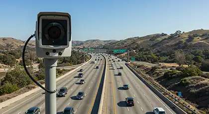
- Live Traffic Cameras
- Real-time camera images show current road and construction conditions.
- You can check traffic flow and pick less congested routes before starting your trip.
| What is QuickMap?
Quickmap is the official real-time map and app of Caltrans, providing lane closures, CHP incidents, cameras, chain controls, and more, with data directly from Caltrans/CHP. |
How To Use Caltrans QuickMap For Work Zone Safety
Caltrans QuickMap provides travelers with live updates on traffic and road conditions using interactive map markers. These icons indicate construction zones, lane closures, and traffic incidents. With this information, drivers can make informed decisions when traveling through work areas.
Under California law, a “work zone” is any part of a highway where construction, maintenance, or utility work is occurring. Signs, cones, or barriers must be present to guide or warn drivers in these areas.
To use QuickMap, follow these steps:
- Open QuickMap — Visit quickmap.dot.ca.gov or download the free app for Android or iPhone from the Apple App Store or Google Play Store.
- View the Map Markers — Look for icons showing construction zones, lane closures, or CHP incidents.
- Click a Marker — Select an icon to open a pop-up window with detailed information about that location.
- Use the “Options” Menu — Turn data layers on or off to customize what you see, such as traffic speed or road conditions.
- Check the Legend — The options menu also serves as a legend, explaining the meaning of each icon.
- Review Multiple Layers — Explore different map layers to check live traffic updates, road closures, and local incidents.
QuickMap’s real-time layers help travelers stay informed, avoid hazards, and drive more cautiously near work zones.
Real-Time Traffic Information
The following updates keep drivers alert and ready when heading toward road construction zones. You can check:
- Live traffic speeds and slowdowns on your route.
- Active lane closures and detours across the freeway.
- Truck restrictions and commercial vehicle updates.
- Current roadwork or maintenance alerts from Caltrans.
QuickMap organizes everything by location and event, so you can easily find what’s happening before you roll into a work zone.
Facilities Layer
The “Facilities” layer focuses on permanent highway features and dynamic information sources that update in real time. This combination helps drivers plan safer journeys through or around work zones.
Key features in the facilities layer:
- Electronic Message Signs — This feature shows all active Changeable Message Signs (CMS) with important updates about work zones, lane closures, and detours. When you click a marker, you can see the exact message displayed on that sign.
- Traffic Cameras — This feature provides still images from cameras placed along California highways. You can check road conditions before entering a work zone and see if traffic is slow, lanes are blocked, or the weather is causing problems.
- Rest Areas — Find nearby rest stops where you can take breaks and prevent driver fatigue. Resting is especially important when driving through areas that need extra attention.
- Park & Ride Lots — Locate carpool areas that help reduce the number of vehicles passing through construction zones.
- County Boundaries — View clear boundary lines showing which local agencies manage each section of the road. This feature is helpful when you need emergency or maintenance assistance near work zones.
Road Conditions Layer
Road conditions can change rapidly due to construction activities, maintenance operations, traffic accidents, or severe weather events. During National Work Zone Awareness Week, various safety initiatives are highlighted to address these risks and promote safe driving in work zones.
However, these changes create potential hazards that require the driver’s immediate attention. The “Road Conditions” layer in QuickMap gives constant updates about these changes. It helps drivers to adjust their speed and drive cautiously through or around work zones.
Crashes in work zones can be very dangerous for both drivers and road workers. The Federal Highway Administration reported 891 work zone fatalities in 2022. This report illustrates the importance of driver awareness in construction areas.
The Caltrans mobile map gives clear alerts about active construction zones. These updates help prevent serious collisions near a construction site.
Traffic Speed

QuickMap uses an intuitive color-coded system to display real-time traffic speeds across California highways, allowing drivers to identify congestion points near work zones before encountering them. This visualization combines data from multiple reliable sources:
- Google Maps Traffic Layer
- Caltrans’s traffic management systems
- Automated Vehicle Location (AVL) technology
The color-coding system makes speed information instantly understandable:
- Green — Normal traffic flow (55+ mph on highways)
- Yellow — Minor congestion (35-54 mph)
- Orange — Moderate congestion (20-34 mph)
- Red — Heavy congestion (0-19 mph)
Safety Impact For Work Zones
Sudden traffic slowdowns in construction areas significantly increase the risk of rear-end collisions. The risk increases when drivers are distracted or following too closely. If you’re unsure about speed limits near work zones or in general, learn what is considered speeding in Los Angeles.
According to the Federal Highway Administration, about 21% of all work zone accidents are rear-end collisions.
Common injuries from these crashes include:
- Whiplash or neck strain
- Head and brain injuries
- Spinal cord injuries
You may be eligible to file an injury claim if poor work zone management or missing warning signs caused the crash. Workers who sustain workplace injuries in these accidents may also seek compensation. These include medical expenses, lost wages, pain and suffering, and other damages. Car accident lawyers can explain your options under California law.
Lane Closures
Sudden, unexpected lane closures contribute to motor vehicle accidents, especially in high-traffic corridors. The “Lane Closures” layer in QuickMap provides daily commuters with comprehensive information about current and scheduled construction or maintenance activities.
This feature allows motorists to:
- Plan alternative routes before encountering work zones.
- Prepare for necessary lane changes well in advance.
- Avoid dangerous last-minute merging in construction areas.
- Budget extra travel time for affected routes.
QuickMap offers a “Planned Lane Closures” option in the menu, which displays scheduled work up to one week in advance for those planning future trips. Users can visit the Caltrans website for additional details on longer-term construction projects.
Legal Implications Of Improper Work Zone Management
Poorly marked or unmaintained construction zones can put both drivers and workers at risk. Missing signs, barriers, or warnings increases the likelihood of accidents.
- Government agencies are liable for unsafe road conditions if they knew or should have known about a hazard but failed to fix it.
- Contractors are responsible when errors in setting up or maintaining a work zone cause an accident.
For private property, premises liability laws usually apply. Property owners are responsible for maintaining a safe environment for their visitors.
However, public projects follow different rules. Claims against government entities must be filed under the California Government Claims Act. This process has strict deadlines and documentation requirements.
If a poorly managed work zone caused your injury, you can seek legal guidance. A premises liability attorney can explain your options. They can also guide you through the legal steps.
| Liability for Unsafe Work Zones
Under the California Government Code, public agencies may be liable for known road hazards. Contractors can also face liability for negligent setup or maintenance. Deadlines to file claims apply. |
California Highway Patrol Incidents
Traffic incidents reported by the California Highway Patrol are represented by distinctive red triangular markers on the QuickMap interface.
These real-time updates provide critical warnings about the following:
- Vehicle accidents near work zones.
- Disabled vehicles that block lanes.
- Debris on roadways.
- Flooding or weather-related hazards.
- Emergency construction or repair activities.
This information enables drivers to stay alert to developing situations, drive appropriately, and adjust routes when necessary to avoid areas with increased risk of work zone crashes, truck accidents, or motorcycle collisions.
When you click on a CHP incident marker, a detailed information window appears showing:
- The exact location of the incident.
- When it was reported.
- A description of the situation.
- The current status of emergency response.
- Estimated duration (when available).
Having this information before encountering a problem area gives you valuable time to make safer driving decisions.
Caltrans Highway Information Network (CHIN) Incidents
Lane closures in work zones significantly increase the risk of specific accident types:
- Sideswipe accidents during lane changes.
- Rear-end crashes due to unexpected slowdowns.
- Multi-vehicle pileups in congested areas.
These crashes often occur due to low visibility, sudden traffic changes, and confusing lane configurations. The National Work Zone Safety Information Clearinghouse reports over 39,000 injuries in work zones each year.
The CHIN layer shows closures and roadwork with orange triangle icons. Unlike CHP incidents, which show crashes and emergencies, CHIN markers focus on:
- Planned lane closures due to construction.
- Emergency road repairs.
- Bridge work and inspection activities.
- Utility work affecting traffic flow.
This information helps drivers prepare to slow down appropriately, execute lane changes safely, and minimize the risk of accidents in construction zones. When you click a CHIN marker, you’ll see which roads are closed and how long the work will last.
Commercial Vehicles Layer
The “Commercial Vehicles” layer gives important information for truck drivers using California’s highways. It includes tools that help commercial drivers:
- Travel safely through work zones.
- Avoid restricted or hazardous roads.
- Find emergency routes quickly.
- Stay compliant with state trucking rules.
Key Features For Commercial Drivers
The Commercial Vehicles section gives truck drivers useful tools for safe and compliant travel near construction zones:
- Truck Weigh Stations Layer
- Displays the locations and open/closed status of inspection stations across California.
- Helps drivers follow weight rules and avoid entering work zones with overloaded trucks.
- Truck Escape Ramps Layer
- Shows emergency ramp locations for trucks with brake failures on steep roads.
- Helpful in mountain areas where road layouts often change.
- STAA Truck Routes (TA/SA) Layer
- Highlights approved routes for larger trucks.
- Keeps drivers from entering restricted roads with low bridges or tight turns.
- California Truck Networks Layer
- Displays color-coded truck routes by size and type.
- Helps drivers avoid restricted or unsafe areas near construction zones.
The California Truck Networks are color-coded for quick reference:
| Color | Type |
| Green | National Network Route (STAA) |
| Blue | Terminal Access Route (STAA) |
| Black | California Legal Route |
| Yellow | California Legal Advisory Route |
| Red | Special Restriction Route |
California law requires commercial drivers to:
- Follow designated truck routes.
- Stop at open weigh stations.
- Obey posted work zone restrictions.
Failing to comply with these rules can result in fines, citations, or liability if a crash occurs in a restricted area. Using QuickMap’s “Commercial Vehicles” layer helps drivers:
- Stay compliant with state laws.
- Avoid restricted roads.
- Travel safely near active construction zones.
Warning Indicators For Commercial Drivers
A red triangle warning symbol lets truck operators know about potential hazards, including:
- Low bridge clearances.
- Temporary roadblocks affecting commercial traffic.
- Turning restrictions for long vehicles.
- Weight-restricted bridges near construction zones.
Ignoring these warnings can cause serious crashes that put both drivers and road workers at risk. Since trucks are larger and heavier, collisions can lead to:
- Severe or catastrophic injuries.
- Major property damage.
- Road closures and traffic delays.
If a construction worker gets injured in one of these accidents, they may file a workers’ compensation claim to cover medical bills and lost income. By using every available layer in the Commercial Vehicles section of QuickMap, truck drivers can:
- Plan routes that avoid restricted roads.
- Stay aware of hazards near active work zones.
- Prevent common types of truck accidents and injuries.
Other Types Of Traffic Information
Caltrans QuickMap gives drivers several ways to access important traffic updates beyond the map view. You can choose the option that works best for your needs:
- Interactive Map View — See live traffic, lane closures, and construction zones.
- Text or Voice Updates — Get simple written or spoken summaries of closures, detours, and roadwork.
These options help you adjust your route and drive cautiously around work zones and dangerous road conditions.
Map View Options
QuickMap provides several map visualization styles. These options allow users to choose the most effective view for tracking traffic flow and construction activity. By selecting the most appropriate display type for current conditions, travelers can enhance their situational awareness and reduce the risk of work zone accidents.
- Satellite View — This view displays detailed Google Earth satellite imagery. It offers a realistic overhead perspective of roadways and construction zones. It also allows users to assess the following:
- Actual terrain conditions.
- Traffic congestion patterns.
- Physical extent of construction sites.
- Satellite + Labels — This view enhances satellite imagery with clearly marked street names and location identifiers. It helps you recognize specific landmarks and exit points near work zones more easily.
- Terrain View — This view overlays topographical details on the standard road map. It helps drivers anticipate elevation changes that may impact driving safety. This view is particularly valuable when navigating mountainous regions with ongoing construction work, where steep grades might compound the challenges of lane restrictions.
Voice And Text-Based Traffic Information
When you can’t use the map or want to plan your trip, QuickMap offers other easy ways to get traffic updates.
- Highway Conditions Webpage — The highway conditions webpage enables users to enter a highway number to view real-time updates on roadwork, lane closures, and detours. This text-based format is particularly valuable for:
- Planning trips in advance.
- Checking conditions when mobile data is limited.
- Quickly scanning multiple routes for the best option.
- Voice-Based Traffic Information — Travelers can call the dedicated hotline at 1-800-427-7623 for audio updates. This hands-free option ensures drivers stay informed even when they can’t safely view their mobile devices. The service provides crucial details on:
- Active lane closures that affect traffic flow.
- Caltrans Highway Information Network alerts.
- Current chain control requirements in mountain passes.
- Major construction projects that impact travel times.
This audio service does not include CHP incident reports. However, it gives the key information needed to avoid major delays and hazards in work zones.
Quickmap Navigation
QuickMap makes it easy for drivers, commuters, and truck operators to find location-specific information. It offers convenient “Zoom To” shortcuts that enable users to quickly view major cities and regions across California.
Regional Shortcuts
The platform offers one-click access to these key metropolitan areas:
- Northern California — Redding, Sacramento, and Lake Tahoe
- Bay Area — San Francisco and Stockton
- Central California — Fresno and San Luis Obispo
- Southern California — Los Angeles, San Bernardino, and San Diego
These preset zoom options allow users to view construction activity and changing road conditions. They also make it easy to see traffic accidents in busy cities and major highway routes.
You can use these shortcuts to avoid dangerous work zones, check for sudden road closures, or find better routes around heavy traffic. They give you fast access to the information needed to stay cautious on the road and prevent highway construction accidents.
QuickMap By Caltrans Is Your Go-To App, And It Just Got Better!
Caltrans continues to update the QuickMap platform to make travel in California safer and easier. The app provides real-time information about road conditions, construction closures, and truck routes. It is a valuable resource for commuters, truck drivers, and travelers throughout the state.
Over the years, Caltrans has added several key features to enhance users’ experience with safety information. Here are some of the most notable updates:
Snowplow Tracking (December 2017)
This feature enables travelers to track active snowplows in real-time. It helps improve safety when driving through California’s snow-covered mountain passes in winter. The system shows:
- Live locations of operating snowplows.
- Recently cleared highway sections.
- Plow direction and progress.
- Areas still awaiting clearance.
Knowing where snowplows are actively working allows motorists to make informed decisions about:
- Choosing the safest available routes.
- Timing mountain crossings to follow plows.
- Avoiding areas where plows haven’t yet cleared snow.
- Preventing dangerous situations where vehicles might get stranded in hazardous winter conditions.
For further guidance, check out these winter driving tips from Caltrans.
Push Notifications For Road Closures (August 2022)
This significant enhancement directly delivers proactive alerts about road closures to users’ devices. When a user is within 10 miles of an active closure, the app generates a pop-up notification that contains:
- Precise closure location.
- Estimated start and end times.
- Specific reason for the closure (construction, accident, weather).
- Alternative route suggestions, when available.
This feature enables drivers to:
- Avoid unexpected detours.
- Reduce travel disruptions.
- Plan alternative routes before reaching closures.
- Minimize delays, especially in work zones where last-minute rerouting can impact both safety and schedule efficiency.
Commercial Vehicles Layer (June 2023)
The newest significant addition to QuickMap provides specialized information for commercial truck operators. This comprehensive update includes:
- Weigh station locations and operational status.
- Truck escape ramp positions on mountain grades.
- California’s complete color-coded truck network system.
- Special restriction warnings for oversized vehicles.
By planning safe routes, commercial drivers can lower their risk of commercial vehicle accidents. Following California’s trucking rules also helps prevent crashes near active construction zones.
Tips For Driving Safely In And Around Work Zones
Driving through highway construction or maintenance areas requires extra attention and care. These safety tips can help protect you and road workers:
- Check Before You Drive — Open the Caltrans QuickMap app or website before you hit the road. You can spot lane closures, construction zones, and traffic jams before you even leave your driveway.
- Always Wear Your Seatbelt — Seatbelts save lives. According to the National Highway Traffic Safety Administration (NHTSA), seatbelts cut the risk of deadly crashes for front-seat passengers by 45%.
- Expect the Unexpected — Work zones can change at any time. Stay alert for new cones, lane shifts, or temporary detours, especially in areas with major cities or mountain passes.
- Eliminate Distractions — Put your phone on Do Not Disturb and keep both hands on the wheel at all times. Distracted driving is hazardous in work zones where reaction time is critical.
- Increase Following Distance — Leave at least a three-second gap between you and the car ahead. Add more room if it’s raining or the road’s slick.
- Observe Speed Limits — Those lower work zone limits aren’t suggestions. Narrow lanes and close worker areas make slower speeds necessary for everyone’s safety.
- Follow Directions From Flaggers — When you see flaggers on the job, follow their directions. They coordinate real-time traffic flow to keep cars and crews moving safely.
- Remain Patient and Courteous — Work zone backups are frustrating, especially during rush hour or summer road trips. Take a breath, keep your cool, and remember: those crews are working to make your drive smoother tomorrow.
Questions People Often Ask About Using QuickMap For Work Zone Safety
Here are some common questions and answers about navigating work zones safely with QuickMap. This real-time traffic information tool helps drivers and commuters stay informed, avoid accidents, and understand their rights in the event of a crash.
Many victims search online for free accident lawyer advice, which some law firms may offer through initial consultations or case reviews. If you’d like to discuss your situation, you can call us at (888) 488-1391 for a free case evaluation.
Is It Legal To Use Caltrans QuickMap While Driving?
Using Caltrans QuickMap while driving can violate CA’s distracted driving laws. The California Vehicle Code prohibits drivers from holding or operating a handheld device while driving.
To stay compliant:
- Use Hands-Free Mode — Mount your phone or use voice commands to stay connected.
- Set Your Route Before Driving — Check road and work zone updates in advance.
- Avoid Touching Your Phone — Even brief taps can lead to fines or crashes.
- Pull Over Safely — Stop in a safe spot before adjusting the app.
Use QuickMap responsibly to follow the law and stay focused on the road.
How Often Is The Information On The Map Refreshed?
QuickMap’s data refresh rates vary by information type:
- Most traffic information layers update every 60 seconds.
- Some specialized layers refresh every 5 to 10 minutes.
- The website automatically refreshes every 3 minutes.
During updates, the map may flicker as layers reload with new information. If you have an information window open, it will close automatically to remove outdated data.
How Does QuickMap Determine A User’s Location?
The QuickMap app uses your device’s GPS to show your location and nearby traffic or road closures. The system does the following:
- Check your location approximately every two minutes.
- Send a notification if your position is within 10 miles of an active road closure.
The app doesn’t track your travel history or collect personal information beyond what’s needed for it to work.
Unlike Google Maps or Waze, QuickMap gets its data directly from Caltrans and the California Highway Patrol. It gives you official, real-time updates on closures, construction zones, and safety alerts.
When Should I Merge If A Lane Is Closing Ahead?
When approaching a lane closure in a work zone, the safest approach is to:
- Begin preparing to merge as soon as you see the “Lane Closed Ahead” warning signs.
- Look for a safe gap in the adjacent lane while maintaining your speed.
- Signal your intention to change lanes well in advance.
- Merge when it is safe to do so.
There’s no legal requirement to merge when you see the first warning sign immediately. You can stay in your lane until the closure point, known as a “zipper merge.” However, it’s usually safer to merge early when traffic is moving fast to avoid sudden braking.
What Should I Do If Unsafe Work Zones Are Unmarked Or Warnings Fail?
If you find an unsafe or unmarked work zone, slow down and stay alert. Once safe, report the hazard to Caltrans through the Customer Service Request (CSR) system with details or photos. If an accident occurs, document the scene and consult a personal injury lawyer to review possible liability under California law.
What Should I Do If I Get In An Accident In A Work Area?
Call 911 immediately to report the accident and request medical help. If you’re involved in a work zone accident, follow these steps to protect your safety and legal rights:
- Move to Safety When Possible — First, assess yourself and any passengers for injuries. If your vehicle is drivable and safe, move to a secure location away from active traffic, such as a highway shoulder or nearby exit. Activate your hazard lights to alert other drivers and reduce the risk of secondary collisions.
- Exercise Caution Outside Your Vehicle — Construction zones pose additional hazards compared to regular roads. You may encounter uneven surfaces, heavy equipment, or narrow shoulders. If you need to leave your car, stay alert and keep a safe distance from moving traffic.
- Seek Medical Evaluation — Even if you feel fine, some injuries may not appear immediately. A medical checkup can detect hidden injuries and create records that may be helpful in insurance or legal claims.
- Document the Scene Thoroughly — If it’s safe to do so, take photos or videos of:
- Vehicle damage.
- Any dangerous road conditions.
- Construction signage and work zone configuration.
- Any apparent hazards or visibility issues.
Additionally, you should request the contact information of witnesses who may have witnessed the accident.
- Report the Incident Properly — File a police report and notify your insurance company promptly. Provide factual information about what occurred without speculating about fault or liability.
- Consult with an Attorney — If you’ve sustained injuries or experienced significant property damage, you might be wondering, “Do I need a personal injury lawyer?” An attorney with experience in work zone accidents can help protect your rights and interests. Legal counsel can:
- Assess liability.
- Assist with insurance claims.
- Review possible negligence in work zone management.
- Help pursue compensation allowed under California law.
What Proof Do I Need For A Legal Claim After A Work Zone Accident?
You’ll need evidence showing that negligence caused your injuries. Helpful proof includes:
- Photos or videos of the crash scene, damaged vehicles, and missing or unclear signs.
- Police and Caltrans reports about the work zone setup.
- Witness statements.
- Medical records linking your injuries to the accident.
A car accident attorney can help gather and preserve this evidence to support your claim.
Injured On The Road? Contact Arash Law For A Free Case Review

Accidents in construction or work zones can result in serious injuries and unexpected expenses. If another driver, contractor, or agency acted carelessly, you may have the right to seek compensation for your medical bills, lost income, and other related losses. Understanding your legal options can help you take the right steps after a crash.
The legal team at Arash Law assists people injured in traffic accidents across California, including those involving construction or maintenance zones. Our attorneys provide professional guidance through the claims process and help protect your rights under state law. To schedule a free initial consultation, call (888) 488-1391 or complete our “Do I Have A Case?” form.